The map was envisaged by Anca, one of the volunteers, who was supported and helped by Kate. See more about both of them in the About us page.
We hope that you look at the map and reflect at the different places the children are from and consider how their perception of the world was shaped by their experiences. If you want to know more, below the map is a description written by Anca.
Map
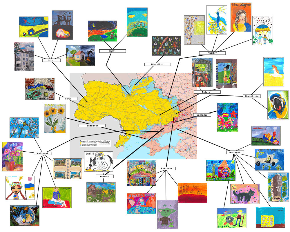
After interacting with the children and learning part of their stories, I wanted to understand and reflect how they see themselves. This is how the idea of the map started, and for which I received a lot of help from Kate, making sure the paintings are attributed to the correct location. The map is a tool of contextualizing the experiences of the internally displaced children, who made Lviv their home. Unlike other ways of adding context to a body of art, which are focused on either the story of the author(s) or the subject(s) being painted, the map offers a glimpse into what children value based on the place they came from. We are all shaped, in part, by the place that we were born in and called home as children. This is integral to how we see ourselves, regardless of our age or gender. I wanted to reflect this in the map, and I did not include any additional information, as it would create noise making the viewer lose focus.
The places have their language and specific accents, local idioms, games, and the specificity that allows for that well known familiar comfort of belonging. Children who are displaced by the war lost that, even if they are still in their own country. In Ukraine this can also mean changing or questioning the language people use. In the decade before the full-scale invasion almost half of the population was using russian as their mother tongue, a trend that decreased after the invasion of 2014. Since 2022 this downward trend accelerated.
The map highlights these shared experiences and the values the children have. It shows that some of the children originally from the western parts, who were not under occupation and constant bombardment are feeling the pain and terror of the air alerts and deaths. It also shows that some of the children are thinking of the moments of joy they had, a favourite toy, a beloved pet. It might take decades for them to be able to return to the cities they were from, or maybe it might never happen. Some of these places are completely destroyed and even without being occupied, there are no buildings, no infrastructure, there is nothing left.
To create the map, I have decided to choose a random one, from the first quarter of 2025. It shows the realities on the ground as they were, a snippet in time. It shows how much territory was liberated by the Ukrainian army, in blue. It also shows the dynamic of fighting, as the red dots and arrows mark the fighting over the previous 24 hours. It is a fix moment in time, and, simultaneously, it also highlights the situation over the past couple of years. Due to the bravery of the Ukrainian soldiers, the frontline is virtually unchanged despite constant attacks on different points on the contact line.
Each month more paintings are created, digitized, and catalogued, creating an important collection from a historical point of view. The map will reflect that as it will also change to included new artwork.